Use Free Mapulator App to Calculate Distance between Two Points on Map Like a Pro!
Knowing how to calculate distance between two points on a map can be incredibly useful, whenever you’re planning a road trip, measuring the distance of your morning jog or simply trying to find the shortest route to your favorite restaurant. Fortunately, with the help of modern technology and a few basic principles of geometry calculating distances on a map has never been easier.
In this article, we will guide you step-by-step through the process of calculating distance between two points on a map using Mapulator App. Whether you’re a seasoned traveler or a novice map-reader, you’ll soon be able to determine distances with ease and accuracy.
Getting Started
To use this easy method for calculating the distance between two points on a map, you’ll need a few things.
- First, make sure you have a mobile device running either Android or iOS.
- Next, you’ll need to know the coordinates of the two points you want to measure the distance between. Don’t worry if you don’t have them handy – you can also find the points manually on the map or use their street addresses.
- Lastly, you’ll need to download the Mapulator App. Which is available for both Android and iOS.
Easy Method Calculate Distance between Two Points
The easy method for calculating distance on a map involves using a website or app that provides a distance calculator with accuracy. There are many websites and apps available but we’ll focus on using Mapulator App as it is widely used and available for free. Mapulator has different inbuilt methods/tools to find the distance of any two points or addresses.
With Mapulator App it offers these 5 Easy Methods to Calculate Distance between Two Points on Google Map or Apple Map.
- Method 1: Using Screen Tap
- Method 2: Using Scope
- Method 3: Using Draw
- Method 4: Using Coordinates
- Method 5: Using GPS Live
Method 1: Using Screen Tap
Step 1: Open the Mapulator app then click on create a new project option.
Step 2: Click on the gear icon at the top right corner of the screen to access the settings menu. then you can choose the appropriate map type, area unit, distance unit, line color and fill color. Once you have made your selections then click the back arrow button at the top left corner to go back to the main screen.
Step 3: At the bottom right corner of the screen click on the second button which is labeled Distance Calculation.
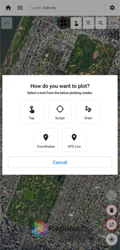
Step 4: Click on the first icon next to the compass at the top of the screen then select “Tap Mode.”
Step 5: Tap on the screen to mark your starting and ending location points then the distance between the two points will be displayed on the screen. To finalize your results then click on the checkmark icon.
Method 2: Using Scope
Step 1: Open the Mapulator app then click on create a new project option.
Step 2: Click on the gear icon at the top right corner of the screen to access the settings menu. then you can choose the appropriate map type, area unit, distance unit, line color and fill color. Once you have made your selections then click the back arrow button at the top left corner to go back to the main screen.
Step 3: At the bottom right corner of the screen click on the second button which is labeled Distance Calculation.
Step 4: Click on the first icon next to the compass at the top of the screen then select “Scope Mode.”
Step 5: Use two fingers to scroll the map and move the scope to the location Points where you want to measure the distance. After that you click on the fourth red button at the bottom right corner of the screen to mark your starting and ending points. The distance between the two points will be displayed on the screen. To finalize your results click on the checkmark icon.
Method 3: Using Draw
Step 1: Open the Mapulator app then click on create a new project option.
Step 2: Click on the gear icon at the top right corner of the screen to access the settings menu. then you can choose the appropriate map type, area unit, distance unit, line color and fill color. Once you have made your selections then click the back arrow button at the top left corner to go back to the main screen.
Step 3: At the bottom right corner of the screen click on the second button which is labeled Distance Calculation.
Step 4: Click on the first icon next to the compass at the top of the screen then select “Draw Mode.”
Step 5: Use two fingers to scroll the map to the location points where you want to measure the distance. After that you click on the fourth red button at the bottom right corner of the screen to activate the drawing tool. Mark your starting and ending points by drawing a line or swinging your finger on the screen. The distance between the two points will be displayed on the screen. To finalize your results then click on the checkmark icon.
Method 4: Using Coordinates
Step 1: Open the Mapulator app then click on create a new project option.
Step 2: Click on the gear icon at the top right corner of the screen to access the settings menu. then you can choose the appropriate map type, area unit, distance unit, line color and fill color. Once you have made your selections then click the back arrow button at the top left corner to go back to the main screen.
Step 3: At the bottom right corner of the screen click on the second button which is labeled Distance Calculation.
Step 4: Click on the first icon next to the compass at the top of the screen then select “Coordinates Mode.”
Step 5: Use two fingers to scroll the map to the location points where you want to measure the distance. After that you click on the fourth red button at the bottom right corner of the screen to activate the coordinate entry tool. Enter the right latitude and longitude coordinates of your starting point and then click the red button again to enter the coordinates of your ending point. The distance between the two points will be displayed on the screen. To finalize your results then click on the checkmark icon.
Method 5: Using GPS Live
Step 1: Open the Mapulator app then click on create a new project option.
Step 2: Click on the gear icon at the top right corner of the screen to access the settings menu. then you can choose the appropriate map type, area unit, distance unit, line color and fill color. Once you have made your selections then click the back arrow button at the top left corner to go back to the main screen.
Step 3: At the bottom right corner of the screen click on the second button which is labeled Distance Calculation.
Step 4: Click on the first icon next to the compass at the top of the screen then select “GPS Live Mode.”
Step 5: GPS Live will use your current location on the map as your starting point. After that you click on the fourth red button at the bottom right corner of the screen to activate the GPS Live Tracking/Recording feature. Start moving towards your ending point and the distance between the two points will be displayed on the screen in real-time. Once you reach your ending point then click on the checkmark icon to save your results.
Tips to Calculate Distance between Addresses
To get the most accurate distance measurement using Map then user must ensure that the route between the two location points is as straight as possible. If the route between the two points is not straight, then you should zoom in and mark the points carefully. If the route between the two location points is curved then you can add and join multiple points. However, it is recommended to avoid adding additional points to the route as this can affect the accuracy of the measurement. Also, one must make sure that you have selected the correct unit of measurement for the distance.
Advantages of the Mapulator App
The easy method of calculating distance on a map has several advantages.
- The app is free and user-friendly making it accessible to anyone.
- It provides accurate and reliable distance measurements helping you plan your routes and trips.
- The app can be used globally as long as you have access to a map and the internet.
- It can also measure the area of a region on a map. Which can be beneficial in various fields such as real estate or surveying.
- Outdoor enthusiasts like hikers or bikers can use the app to track their progress and distance traveled.
- Businesses can use the app to calculate delivery distances or determine the proximity of potential customers.
- You can save your project and share it with anyone.
Conclusion
Manual calculation of distances on a map can be time-consuming and challenging, but with the Mapulator app, it doesn’t have to be. The easy method we’ve shown you makes it quick and accurate to calculate the distance between two points. Give it a try the next time you need to find the distance between two places on a map.