
If you're picking a land surveyor app, the decision really comes down to five things: how accurate the GPS/GNSS reading is, whether it works offline, what file formats it supports (KML, GeoJSON, shapefiles), which platform you're on, and what it costs relative to how often you'll actually use it. Get those five right for your specific job — a quick property line check is a very different need than a construction stakeout — and you'll avoid the two most common mistakes: overpaying for survey-grade features you don't need, or underbuying and getting inaccurate results on a job that mattered.
What actually matters when comparing land surveyor apps
GPS/GNSS accuracy: Consumer-grade phone GPS is typically accurate to within a few meters — fine for rough area estimates, not fine for anything with legal or construction implications. If precision matters, look for apps that support external GNSS receivers or RTK correction.
Offline capability: Rural sites and large parcels often mean no signal. An app that needs a live connection to load maps or save data will let you down exactly when you need it most.
File format support: If you're handing data off to a CAD system, GIS platform, or another surveyor, KML and GeoJSON import/export isn't optional — it's the difference between usable data and a screenshot.
Platform: Obvious, but worth checking before you download: some tools are iOS-only, some Android-only, a few work on both.
Pricing model: One-time purchase, subscription, or free-with-limits — match this to how often you'll actually use the app. A subscription makes sense for daily fieldwork; a one-time purchase makes more sense for occasional use.
Land surveyor apps compared
| App | Best For | Platform | Offline Use | Pricing |
|---|---|---|---|---|
| Mapulator | Quick land area/distance measurements, marking plots on satellite maps | iOS, Android & Web | Yes | Free tier + paid plans |
| LandGlide | Looking up property lines and parcel data | iOS & Android | Limited | Subscription |
| GPS Fields Area Measure | Simple field/land area calculations | iOS & Android | Yes | Free + in-app purchases |
A quick honest note: LandGlide is strongest specifically for U.S. parcel and property line lookups sourced from county records and less useful outside that use case. GPS Fields Area Measure is the closest direct match to Mapulator in terms of what it does, so if you're choosing between the two, it mostly comes down to interface preference and export format needs.
Which land surveyor app fits your situation
- Need a fast area or distance measurement on a satellite map, no special hardware? Mapulator or GPS Fields Area Measure will cover it.
- Need to check property boundaries or ownership records? LandGlide is built for exactly that.
- Doing professional survey work that needs centimeter-level, legally defensible accuracy? On their own, none of these three apps get you there. Mapulator is an exception in one specific way — it can take corrected positioning data from an external RTK GNSS receiver (for example, General Laser's GLRM, via a documented Android setup), which meaningfully improves accuracy over phone-only GPS. Even so, for anything that needs to be legally binding, you'll still want a licensed surveyor to sign off on the result.
Why land surveyors and field teams use Mapulator
Mapulator is built for the first case above — fast, accurate measurements without needing extra hardware. A few things worth knowing:
- Works on both iOS and Android, so it doesn't lock you into a device ecosystem.
- Offline-capable with cloud backup when you're back online, so a dead zone mid-survey doesn't cost you the data.
- Supports KML import/export, so your measurements aren't stuck in the app — you can move them into other GIS or CAD tools.
- Real-time GPS tracking for walking a boundary and measuring as you go, not just tapping points on a static map.
- Multiple map sources (Google and Apple Maps, with different map modes) so you're not stuck with one satellite provider's imagery.
- Also available as a web app — no install needed if you just want to measure something quickly from a laptop. Here's what that looks like in practice. Below is a plot measured with Mapulator's Tap Mode, before and after boundary marking:
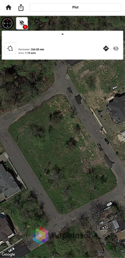
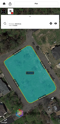
What took a walk around the property with a tape measure or a call to a surveyor for a rough estimate now takes under a minute.
It's not trying to replace survey-grade GNSS equipment for legal boundary surveys — for that, you still need a licensed surveyor and proper hardware. What it's good at is everyday measurement: estimating a plot before a project starts, checking a rough boundary, or getting an area calculation without booking a professional for something simple.
Common Questions About Land Surveyor Apps
Is there a free land surveyor app?
Yes — most apps in this space, including Mapulator and GPS Fields Area Measure, offer a free tier with basic measurement tools. Paid plans usually unlock cloud storage, advanced export formats, or higher usage limits.
Can I use my phone's GPS for an accurate land survey?
For rough estimates, yes. For anything with legal or construction stakes — property boundaries, building permits, disputes — phone GPS alone isn't accurate enough. You'll need an external GNSS receiver or a licensed surveyor.
What's the difference between using an app and hiring a land surveyor?
An app gives you a fast, low-cost estimate you can do yourself. A licensed surveyor provides legally recognized, precision-verified boundary data using professional-grade equipment. Use an app for planning and estimates, but always hire a surveyor when the result needs to hold up legally.
Do these apps work without an internet connection?
Most, including Mapulator, support offline use for measuring — you'll just need connectivity to load new map imagery or sync data to the cloud afterward.
Reviewed by the Mapulator team, based on hands-on use across construction, real estate, Agriculture (Farming) and field-mapping projects.